
OVERVIEW
The Shut-In trail has an interesting history. Originally, around 1890, it was created by George W. Vanderbilt to link his Biltmore home with his hunting and outdoor lodge at Buck Springs (Near the current Pisgah Inn). While many think of this trail as following the Blue Ridge Parkway, it's actually the other way around, since the parkway wasn't built until the 1930's. Since it does parallel the parkway, it has a certain benefits, not the least of which is you're never very far from help. It follows the series of ridge lines from the French Broad (mile marker 393.5) at about 2,000 ft. elevation to the Pisgah Inn (mile marker 408). I've divided it into several smaller hikes because it's an easy drop-off, and pick-up by car. That way, if you want to hike while somebody picnics or stays car-bound, they can pick you up at a designated spot.
The disadvantages have the same source as the advantages. You're never more than 1/2 mile from the parkway, and during peak season, the traffic is very apparent. It can also be crowded, as its very close to Asheville, and a common place for joggers and walkers. That doesn't have to be a disadvantage, if you don't mind leaving humanity not that far away. Another advantage, is that you can plan your hike for as short or long as you feel comfortable for the day. You can easily do a portion of this hike, as i have added notes (and arrows on the map) where the trail splits to connect with the Blue Ridge Parkway by Mile Marker connections. The way I've annotated the trail is as if you were hiking south towards Pisgah Inn.
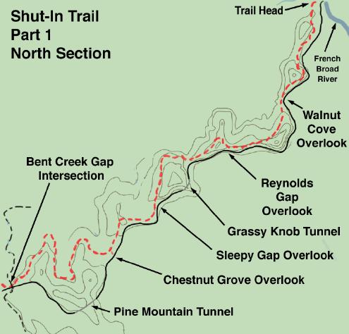
The gradient lines are for reference and not entirely accurate.
MILE MARKER 393.6 - French Broad River
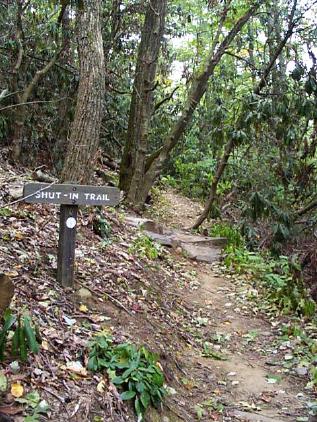
The start of the Shut-In Trail actually begins off the parkway. Take the exit for NC 191 (Brevard Road) and you will pass the trail-head on your left just before you get to the entrance of the North Carolina Arboretum. It is best to park your car down at the Bent Creek park, so continue on and go right at the light. Then take your immediate left to get a view (and spend some time) looking up close at the French Broad River. Also, the Arboretum is a great place for the people driving the car to spend time while you're hiking, if that's the manner in which you'll get picked up. To start on the trail, follow the path that leads thru the bridge under NC 191, cross the street and go left until you see the trail-head (See picture above). Since this is a moist area with lots of moss and fallen trees, keep on the lookout for shelf fungus and cantrelles along the way.
You may have noticed already that you're passing thru Rhododendron thickets alternating with hardwood forests. This is characteristic of this trail, and you'll be going thru parts of the Bent Creek Research Forest. The trail follows the hollow of Bent Creek for a while until you come to a gated fence. Rather than continue on into the backwoods of the Arboretum, turn left and follow the path up the hill to where it again intersects with the Shut-In trail. This, and the next part is the most difficult part of the trail because you're heading up the mountain to the ridge. Notice that some trees are marked and others have experiments ongoing with them, but don't disturb any of that, please. This part of the trail should be called Walnut Way because of all the black walnut trees around. If it's late in the season squirrels will be squandering these and the chestnuts around. The trail is well-kept and marked with white dots of paint on trees. About 1/2 way up the ridge, you will see a side logging road splitting off to the left. Follow it left and continue around the mountaintop.
Once up the ridge, you won't have to do any strenuous hiking as the trail follows the ridge and has ups and downs, but no major climbing. You will be working yourself slowly up from 2,000 feet at the river to 2,700 around Glenn Bald and the trail will be wide and road-like. During non-summer times you will get forest views (by that i mean semi-obstructed by trees, but pretty views nevertheless) of both sides of the mountain. To your left will be Walnut Cove and to your right is the Bent Creek Research Forest. You will see the parkway come into view after about 3 miles. This is the Walnut Cove Overlook.
MILE MARKER 396.4 - Walnut Cove Overlook
Walnut Cove (looking to the east) is a pretty cove of farms and houses that takes one back to simpler times. The trail is across the street to the north. Go left at the intersection. At this point the trail veers away from the parkway, and even during heavily trafficked times, you're walking on the other side of Lance Mountain and won't be bothered by voices or traffic. This short segment of the trail is pretty and relaxing. After a while you'll come close to the parkway again and after a mile you will come to the parking for Reynolds gap.
MILE MARKER 396.8 - Reynolds Gap
The trail on is again on the other side of the parkway from the overlook, continue on left (West) and up the slope above the overlook. Once at the top, turn back towards where you came and if the trees part the right way, you'll get a pretty far-off view of Biltmore tucked in the woods against a backdrop of the mountains. You'll be going up up and down here, but after a while will leave the comfort of the parkway. From Lance Mountain at 3,002 feet towards Grassy Knob at 3,318 feet, even though you won't go up Grassy knob. This is another quiet and private spot.
MILE MARKER 397.3 - Sleepy Gap
The trail here follows the parkway thru a leisurely stroll and if you're more comfortable with this kind of walk, it's a good opportunity. It's just shy of a mile to Chestnut Grove overlook, and you're never very far from the road to walk back.
MILE MARKER 398.3 - Chestnut Grove Gap
The trail begins on the north side of the parking lot and right away moves away from the road. A sign along the trail indicates that it is 4.7 miles to Beaverdam overlook, but you can plan to stop at Bent Creek before then if that's too long. This part of the trail is more secluded than most of the Shut-In trail, and for that reason is a favorite of mine. Again, you will be alternating between Rhododendron thickets and open hardwood forests. It's interesting to go from the dark twisty thickets with misshapen trunks and deep soft mosses to wide open dappled oak and poplar forests blanketed with ferns and crunchy leaves. You will be weaving in and out of little coves with intermittent streams, but nothing at all too difficult to cross.
You will come to a trail off to the right, down the mountain that is Chestnut Grove Trail - blazed orange, but continue on for Shut-In trail. Take the time to notice the rattlesnake weed and varieties of fern (New York Fern, Northern Maidenhair Fern, Christmas Fern, even some Bracken in sunnier areas), along with the little saplings of Sassafras, banks of Solomon's Seal, Galax, and by the moist protected coves, Jewelweed. As you round the last knob, you should see pretty views of Ferrin Knob. As you turn into the cove, you will cross a gravel road. This is Bent Creek Gap Road, and a lovely place for someone to be waiting in their car for you. Turn left on the road to go up to the parkway.
MILE MARKER 400.3 - Bent Creek Gap Road
Just north of where Bent Creek Gap Road exits, there is a small trail leading to the Shut-In Trail. Either that, or start off on Bent Creek Gap Road itself, to the north. You will be working your way up towards Ferrin Knob, and away from the parkway and its noise. You will be going from about 3,200 feet to 4,060 feet in about a mile, so take it slow. Take time to notice some of the larger trees, old bristly oaks and others that have been around for a long time.
Once you reach the top, it becomes grassy and originally there was a fire tower here, built in 1933. Notice too that there's an gnarled apple tree that probably provided many a fire-watcher with a snack. It's funny how the works of man can hardly outlast the power of nature around her. The forest, with it's old trees, is reclaiming it's own back again.
|
|
Work your way down and you'll be at the Beaver Dam Gap parking area. It's not recommended that you use the Blue Ridge Parkway to return here, best to have someone pick you up, because to return you'll have to walk thru 3 tunnels. While i've walked thru them, and the longer Pine Mountain Tunnel, there's just something about tunnels that makes people drive odd. On slow late-season weekdays, a walk thru a long tunnel can surely make you appreciate the full sun and open air of being outdoors. Some of the tunnels have an occasional swallow's nest near the entrance, so look for those. If you have to walk thru a tunnel, it's best to walk on the outside curve. That's the longest part of any curved tunnel, whether facing traffic or not, because you won't surprise any driver by suddenly appearing against a backdrop of cement and reflectors. Recently (1999) a cyclist was killed in one of the tunnels and so walk briskly thru and hope for the best. |
|
|
|
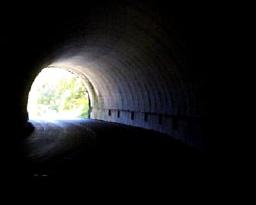
Work your way down and you'll be at the Beaver Dam Gap parking area. It's not recommended that you use the Blue Ridge Parkway to return here, best to have someone pick you up, because to return you'll have to walk thru 3 tunnels. While i've walked thru them, and the longer Pine Mountain Tunnel, there's just something about tunnels that makes people drive odd. On slow late-season weekdays, a walk thru a long tunnel can surely make you appreciate the full sun and open air of being outdoors.
MILE MARKER 401.7 - Beaverdam Gap
The blah blah blah.
DESCRIPTION
This is a very popular hike with locals and visitors. Its parking lot is the same parking lot used for the Fish Hatcheries, and i suspect many people start off on this hike on a lark. It does climb up sometimes a bit steeply, so it is rated 'medium', and probably a few day hikers don't bother trying to make it to the top, which is almost as good as Looking Glass. However, the lowlands, to me, are the best part of the hike anyway. Last time i went on this hike it was late March and the lowland flowers that preferred the rich, open woods were out in profusion. A great collection of trout lillies, many budding mayapples, jack-in-the-pulpits, bloodroot, and down by the creek many early trilliums (trillii?). A very pretty walk.
VIEW
This picture was taken in very early spring before the deciduous foliage came out. You'll be looking out towards the Blue Ridge Parkway, and just over those mountaintops is Graveyard Ridge. To the Northeast you will be able to see the back-end of Looking Glass Rock.